Friends of South Cumberland State Parks
  • What's Happening
  • Plan Your Visit
    • Things to See and Do >
      • Park Overview
      • Park Smarts
      • Tips for New Visitors
      • Trails
      • Day Hikes
      • Overnight Hikes
      • Waterfalls >
        • Winter Waterfalls
      • Overlooks
      • Camping
      • Climbing
      • Caving
      • CCC Interpetive Area
      • Swimming
      • Paddling
    • Resources for Visitors >
      • Trailhead and Trail Info
      • Downloadable Maps
      • Information Center
      • Climbing Areas and Permits
      • Caving Areas and Permits
      • Camping Areas and Permits
      • Campground Reservations
      • Nearby Amenities
    • About the Park >
      • Park Overview
      • Park History
      • Meet the Rangers
      • Hemlock Wooly Adelgid
      • White Fringeless Orchids
      • TN State Parks Website
  • About Us
    • Our Mission
    • Our Leadership
    • Five Year Plan
    • Honorees
    • Friends MeetUp Page
    • Friends YouTube Channel
    • Friends Facebook Page
    • Friends Twitter Feed
    • Friends Instagram Feed
    • Friends Snapchat Feed
  • What We Do
    • Conservation and Protection
    • Trails Team
    • Trail Friends
    • ParkSmarts
    • Back the Rangers Program >
      • Storm Damage Clean Up
    • TN Naturalist Program
    • Fiery Gizzard Trail Reroute
    • CCC Camp Restoration
    • Mack Prichard Legacy Project
    • Trails and Trilliums Festival
    • Goldenrod Gala
    • Picture the Park Photo Contest
    • Every Child in the Park >
      • Healthy Horizons
      • Discover Together
    • Wildlife Programs
    • Hike Challenges
    • Pioneers of the Park
    • Telling the Park Story >
      • Orientation Videos >
        • Park Basics Video
        • Trailheads Video
        • Waterfalls Video
        • Historic Video
        • Camping Video
        • Topography Video
    • Trail Counter Program
  • You Can Help
    • Join the Friends
    • Renew Your Membership
    • Make a Gift
    • Volunteer Opportunities
    • Donate Your Park Photos
  • Member Services
  • Our Partners
  • Contacts

Hike Into History | “Coal Mining in the South Cumberlands”

Highlights for a self-guided hike

Trailhead:  Lone Rock Trail, in the Grundy Lakes area of the park, just off US 41, south of Tracy City, TN  [map]

Coal mining was, for a time, an important part of the economy of this region, from the 1870s until around 1920.  "Mining in the South Cumberlands" takes you to the Grundy Lakes area of South Cumberland State Park, just south of Tracy City, where you can see remains of the beehive-shaped coke ovens where the coal was heated to produce coal coal, which was later used in blast furnaces to make iron and steel.  On the Lone Rock Trail, you'll also see depressions in the hillsides surrounding the lake.  These are remains of many small, narrow mine shafts, called "dog hole mines" because of their small size.  While the discovery of coal in this area generated enough interest to build the Mountain Goat Railroad (to get the ore to market), and was also responsible for the creation of Tracy City, originally a "company town" for the mining industry, ultimately, the volume and quality of coal in this area could not compete with richer deposits found in areas further north, such as West Virginia.  

Leaving the trailhead at the parking area by the lake, here are some of the trail highlights:

The Lone Rock Trail winds through woods, around the main lake, and leads you alongside the coke ovens. This trail has much scenic beauty in addition to its historic sites. Total length of the trail is approximately 1.3 miles, but many shorter walks are possible since it crosses several picnic areas and has numerous road crossings.

Total trail distance:  about 1.3 miles | easy
Picture
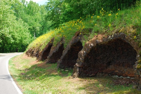
Remains of coke ovens at Grundy Lakes, just south of Tracy City, TN.
Back to "Hike Into History"
©2022 Friends of South Cumberland State Parks, Inc.
Post Office Box 816 | Sewanee, TN 37375

Picture
Picture
Picture