
South Cumberland and Savage Gulf State Parks Trailhead Info
Below is a geographically-organized list of all public trailheads in both South Cumberland and Savage Gulf State Parks. For each trailhead, there is a clickable "map" link to a Google map showing the trailhead parking area; you can also enter these addresses directly into any popular GPS mapping app to help find your way to your hiking destination. You may also want to download this printable set of directions to each trailhead.
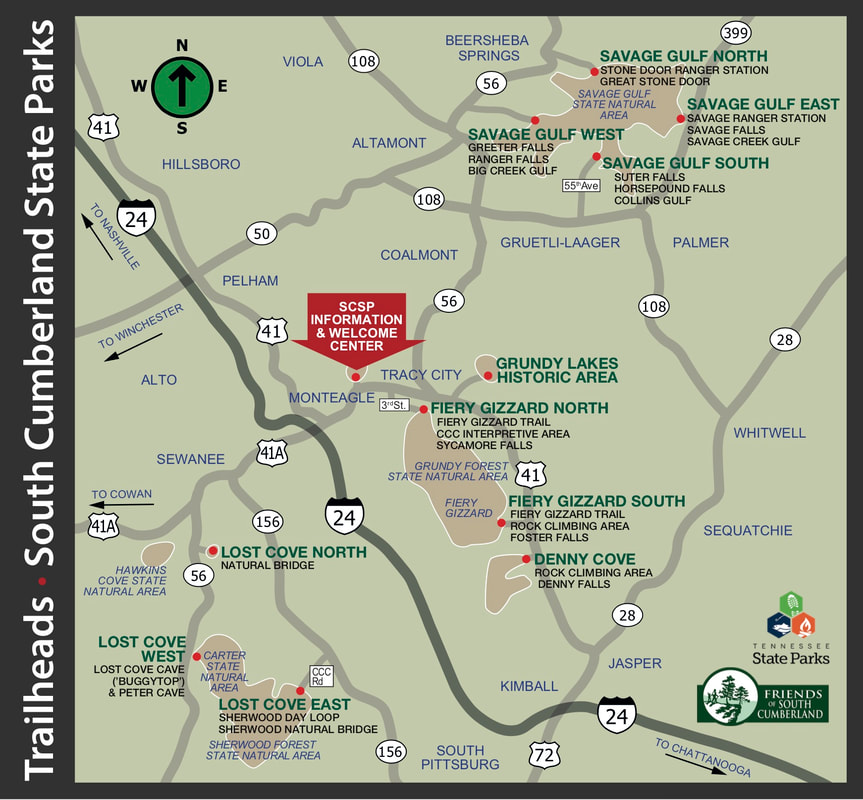
The narrative directions below assume you are coming from the South Cumberland State Park Information & Welcome Center, on Highway 41 in Monteagle. Mileage following each trailhead name indicates driving distance from the Information & Welcome Center. The final approaches to these locations are generally well-marked with large brown ("park-style") roadside signs; however, a few are not so well marked, or are tricky to find; for those locations, we've provided additional navigational tips.
The narrative directions below assume you are coming from the South Cumberland State Park Information & Welcome Center, on Highway 41 in Monteagle. Mileage following each trailhead name indicates driving distance from the Information & Welcome Center. The final approaches to these locations are generally well-marked with large brown ("park-style") roadside signs; however, a few are not so well marked, or are tricky to find; for those locations, we've provided additional navigational tips.
|
South Cumberland State Park
(Opens in a new browser tab or window)
Start your Adventure at the South Cumberland State Park
|
Savage Gulf State Park
(Opens in a new browser tab or window)
––––––––––––––––––––––––––––––––––
Savage Gulf North/Stone Door (23.1 miles) [map] 1183 Stone Door Rd. Beersheba Spgs 37305 Take TN Highway 56 north from Tracy City, through Altamont to Beeersheba Springs (about 20 miles). Look for the large brown park sign, then turn right on Stone Door Road. Follow Stone Door Road about 1.5 miles, out to its end at the Stone Door Ranger Station parking area. What Can I Access from Here? • The Great Stone Door & Overlook • Laurel Falls • Stone Door Campground • Big Creek • Ranger Falls • Decatur Savage Cabin Historic Site • Sawmill Campground • The Big Creek Sink • Big Creek Wildflower Area (spring) • Many Big Creek overlooks –––––––––––––––––––––––––––––––––– Savage Gulf South/Collins Gulf (20.0 miles) formerly known as "Collins West" [map] 2689 55th Ave., Gruetli-Laager, TN 37339 Take TN Highway 56 north from Tracy City, about 10 miles to TN Hwy 108, then right about 5.2 miles on 108. As you come through the community of Gruetli-Laager, watch carefully for the small brown "Collins West" signs marking the 55th Avenue intersection. Turn left on 55th Avenue, and follow it about 2.7 miles, all the way to its end; the parking area and trailhead are directly in front of you. What Can I Access from Here? • Suter Falls • The Collins River headwaters • Collins Campground • Collins River Boulder Field • Collins River Wildflower Area (spring) • Schwoon Spring • Many Collins River overlooks –––––––––––––––––––––––––––––––––– Savage Gulf East/ Savage Creek (24.3 miles) [map] 3177 State Road 399, Palmer, TN 37365 Take TN Highway 56 north from Tracy City, about 10 miles to TN Hwy 108, then right about 7.2 miles on 108 to TN Hwy 399. Left on Hwy 399 about five miles; look for the large brown park sign. The park entrance will be on your left. What Can I Access from Here? • Savage Station Campground • Savage Falls • Savage Falls Campground • Savage Creek • Dinky Line Campground • Werner Big Timber Forest • Hobbs Cabin Campground • The Historic Stagecoach Road • Stagecoach Road Campground • Many Savage Creek overlooks –––––––––––––––––––––––––––––––––– Savage Gulf West/Greeter Falls (18.5 miles) [map] 550 Greeter Falls Rd. Altamont, TN 37301 Take TN Highway 56 north from Tracy City, through Altamont, about 15.9 miles to Greeter Falls Road (marked by a small brown park sign), on your right. Follow Greeter Falls Road about three-quarters of a mile to the parking area, on your left (trailhead is on the right). What Can I Access from Here? • Greeter Falls • Greeter Homestead Historic Site • Long’s Mill Historic Site • Blue Hole Swimming Area • Firescald Creek • Boardtree Falls • Alum Gap Campground • Many Big Creek overlooks |

Other Useful Links
|
Learn more about Climbing in the park
|
Learn more about Camping in the park
|