

Downloadable Maps & Trail Guides
For more info about each of the park's 12 trailheads, including driving directions to each, also see our trailhead information page.

NOTE ABOUT TRAIL GUIDES:
- Fiery Gizzard and Savage Gulf-area trail guides only cover short sections of much longer trails.
- Please pay particular attention to directions, and also always have a trail map with you.
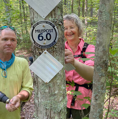
- If you get lost or need help, find one of the mileage marker medallions, posted at half-mile intervals on all SCSP trails, and use the info on it to identify your location to emergency responders.
NOTE ABOUT SimpleMaps™:
These are easy-to-read, simplified and phone-friendly maps showing various sections of trail in the park, including the location of Mileposts and other points-of-interest. Each trail on these maps is color-coded to match the color of the Milepost blazes you'll find every 1/4 or 1/2 mile on SCSP trails. Please take a moment to download the maps that cover the part of the park in which you'll be hiking. They could be a life-saver!
These are easy-to-read, simplified and phone-friendly maps showing various sections of trail in the park, including the location of Mileposts and other points-of-interest. Each trail on these maps is color-coded to match the color of the Milepost blazes you'll find every 1/4 or 1/2 mile on SCSP trails. Please take a moment to download the maps that cover the part of the park in which you'll be hiking. They could be a life-saver!
NOTE ABOUT INTERACTIVE MAPS:
Interactive trail maps and guides are in KMZ file format, and require a free download of Avenza's mobile mapping app. Download it here.
Interactive trail maps and guides are in KMZ file format, and require a free download of Avenza's mobile mapping app. Download it here.
South Cumberland Regional (2-Park) Maps
South Cumberland State Park
Denny Cove Map
Denny Cove Map
Denny Cove Trail Guides
Fiery Gizzard Maps
[KMZ] Fiery Gizzard Interactive Map (map file is 99¢ -- requires free Avenza app)
Fiery Gizzard Trail Guides
Lost Cove Maps
Lost Cove Trail Guides
Other SCSP Maps
Savage Gulf State Park
Savage Gulf Maps
Savage Gulf Maps
Savage Gulf Trail Guides
SPECIAL THANKS
To the Friends of Tennessee State Parks for its mini-grant in support of FSC's Trail Friends and their Trail Guide initiative.
To the Friends of Tennessee State Parks for its mini-grant in support of FSC's Trail Friends and their Trail Guide initiative.
 FSC Trail Team volunteers Ernie Williams and Betsy Miller install one of the final trail markers on the North Plateau Trail in Savage Gulf.
SCSP trail marker system is complete!
After 11 months and 85 miles of carefully measuring the trails in South Cumberland State Park, the Friends of South Cumberland's Trails Team has completed the posting of mile markers on every trail in the 31,000-acre park. The 4-inch metallic medallions each feature trail mileage for the specific trail they mark, as well as a unique location code hikers can use to accurately report their location if they need to call first responders for help. The markers are also color-coded to differentiate adjacent trails from one another.
SCSP Rangers already report several situations where hikers, lost or injured after dark, located one of the new markers and reported the location code on that medallion, not only giving Rangers an exact fix on their location, but considerably shortening the amount of time it would take responders to reach them, and help get them to safety.
Each marker is flanked by two high-intensity reflectors that can be illuminated by light from a smartphone screen at distances of up to 1/10 mile. The mile markers are spaced every half-mile on most trails, and at quarter-mile intervals on the park's most popular trails, so hikers are never more than a few minutes' walk from the nearest marker. The project was funded by the Friends of South Cumberland, with additional support from the Tennessee Trails Association's Highland Rim Chapter.
Other Useful Links
|
Learn more about Climbing in the park
|
|