
Hike Into History | “Railroads in the South Cumberlands”
|
Highlights for a self-guided hike
Trailhead: Savage Day Loop (at the Savage Gulf East trailhead, off TN 399) Palmer, TN [map] The discovery of coal in the South Cumberlands gave rise to the appearance of railroads in this area, built primarily to bring the coal to market. "Railroads in the South Cumberland" will take you to one of these special-purpose railroads, the "Dinky Line," which ran on the north rim of Savage Creek. This narrow-gauge railway brought the coal (and later, timber) out of Savage Gulf, over to Palmer, and on down to Tracy City, where it was transferred to the Mountain Goat rail line, part of which has now been converted to a walking and biking trail connecting Monteagle and Sewanee. As you walk along the Dinky Line, you can still see some of the old cross-ties alongside the trail, which follows the original rail grade for about a mile. Leaving the Savage Gulf East trailhead, here are some of the trail highlights: » 0.4 miles | Suspension bridge above Boyd Branch » 2.0 miles | Rattlesnake Point overlook » 2.2 miles | Junction with North Rim Trail; bear left » 2.5 miles | Suspension bridge across Meadow Creek » 2.6 miles | Junction with North Plateau Trail; bear right » 3.6 miles | Trail follows the old grade of the Dinky Line railroad » 4.8 miles | Mountain Oak trail to the left; continue straight » 5.0 miles | Dinky Line camp area to the right; jeep road crosses trail here At this point, you can turn around and retrace your steps to the trailhead. When you get back to the Savage Day Loop trail, you can take either fork; both bring you back to the trailhead. Total trail distance: about 10 miles | mildly to moderately strenuous |
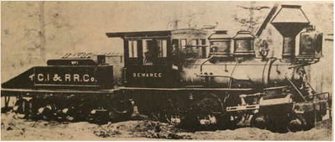
The "Sewanee" was one of the first engines run on the Mountain Goat rail line, which connected the coal mines of Grundy County with the main line at Cowan. "TCI&RR Co.", on the coal car, stands for "Tennessee Coal, Iron and Railroad Company."
|