
Park Overview
South Cumberland and Savage Gulf State Parks
Home to Savage Gulf, Stone Door, Lost Cove and the nationally-recognized Fiery Gizzard Trail
The Cumberland Plateau, the largest remaining forested plateau in the continental United States, is home to South Cumberland and Savage Gulf State Parks. Together, these parks protect over 31,000 acres, includes some of Tennessee's most diverse and spectacular scenery.
First and foremost: Both South Cumberland and Savage Gulf are WILDERNESS parks. Be ParkSmart! Take a moment to be aware of this potentially life-saving information before you head out into the parks!
South Cumberland and Savage Gulf State Parks are comprised of seven discrete tracts scattered across Franklin, Marion, Grundy and Sequatchie counties. As a result, there are 12 trailhead locations from which you can access the different areas of the parks. The parks' tracts are generally clustered in three units: Savage Gulf, in Grundy and Sequatchie Counties; Fiery Gizzard, in Grundy and Marion Counties; and Lost Cove, in Franklin County.
Detailed trail maps are available here, for free download, or in hard-copy form at the South Cumberland Information & Welcome Center, the Stone Door Ranger Station and the Savage Gulf Ranger Station. Or, you can ask for advice from the South Cumberland park office (931-924-2980) or Savage Gulf park office (931-692-3887). You may also want to visit the Tennessee State Parks website to see a listing of scheduled, ranger-guided hikes. Our friendly Rangers and park staff are always available to help. All you have to do is ask!
A popular destination for hikers and campers, South Cumberland and Savage Gulf State Parks have over 85 miles of trails and 13 primitive campgrounds. In addition to hiking and camping, the parks offer opportunities for picnicking, swimming, fishing, caving, visiting historic ruins, rock climbing and rappelling, viewing spectacular rock formations, wildlife and waterfalls.
South Cumberland and Savage Gulf State Parks are truly a unique area of the Cumberland Plateau. These parks plays an important role in protecting and preserving this area’s important natural and historical features and culture. Visitors from all over the world travel to these sites to experience their amazing nature and learn about this area’s history.
With your care and help, the South Cumberland and Savage Gulf State Parks will be able to care for this area for years to come.
South Cumberland Information & Welcome Center
The South Cumberland Information & Welcome Center is an excellent first stop. Located on U.S. Highway 41 between Tracy City and Monteagle, it is approximately three miles east of Interstate 24 and may be reached by taking either Exit 134 or 135 from the interstate. The Information & Welcome Center is about 50 miles northwest of Chattanooga and 85 miles southeast of Nashville.
The Information & Welcome Center provides and excellent interpretation of the South Cumberland's six individual tracts, and highlights the area's history through exhibits, including a cabin, tools relating to the timber industry, photographs, maps, videos and other displays depicting the region's natural and cultural resources. A focal point is a cross-section of a coal mine, as mining was central to the region's economy during the 19th and early 20th centuries. The adjacent grounds include a picnic pavilion, two lighted tennis courts, a playground and a wooded picnic area with grills and tables, and the Meadow Trail, a family-friendly, one mile loop that includes a Nature Play area, and along the way, storybook panels to entertain the kids!
A similar Information & Welcome Center is planned for Savage Gulf. In the meantime, you can get hiking and camping information and all your questions answered at the Savage Gulf State Park Ranger Station, at the Savage Gulf North trailhead (Stone Door).
South Cumberland State Park / Lost Cove / Franklin County
Lost Cove West/Carter State Natural Area (Lost Cove ["Buggytop"] Cave)
The Carter State Natural Area is in Lost Cove, the southwest section of the South Cumberland complex. Hikers can enter the area along the Buggytop Trail, a two-mile long route that leads to the Buggytop opening to Lost Cove Cave. All visitors to the cave are asked to respect the fragile ecology of this underground ecosystem, and stay out of the deeper areas of the cave during bat hibernation season, generally coinciding with cooler weather. The caves are closed during portions of the year in which it is possible for humans to unintentionally pass white-nose syndrome, a disease lethal to bats, to the bat population in this cave. Please respect the information you will find posted on the trail.
Lost Cove North/Natural Bridge
Accessible from State Route 56 and located in the southwest section of the park domain, the Natural Bridge is only a short walk from the parking area. A masterpiece of Mother Nature's handiwork, the 27-foot tall natural bridge has been artfully weathered from solid sandstone by natural forces.
Lost Cove East/Sherwood Day Loop
The nearly 4,000 acre tract, named for the area's most prominent natural feature, is a relatively recent addition to the Park, adjoining both the Carter State Natural Area (Buggytop/Lost Cove Cave) and the University of the South's Lost Cove Conservation Area. This is an easy and rewarding 2.9 mile loop trail that includes a visit to the Sherwood Natural Bridge, unique rock formations, and several outstanding overlooks of the Tom Pack Hollow and Crow Creek valleys, including one of the longest overlook views in the Park, where you can see nearly 17 miles into Franklin County. In the summer, this is a cool and shaded walk; when the leaves are off the trees, the views are even more spectacular.
Hawkins Cove State Natural Area
The Cumberland Plateau is home to a large number of rare and endangered species of plants and wildlife. The Hawkins Cove Natural Area's 262 acres were set aside as a natural area in 1985 to preserve the rare Cumberland Rosinweed. At present, there are no trails or public access points on this tract. Additional information is available at the Information & Welcome Center.
South Cumberland State Park / Fiery Gizzard / Marion & Grundy Counties
Fiery Gizzard Trail
This trail features cascading streams, numerous waterfalls, panoramic overlooks, extremely rocky gorges, gentle slopes and lush woodlands. This trail is one of the most diverse and beautiful in the state and has been ranked as one of the top twenty-five backpacking trails in the United States by Backpacker magazine. There are three primitive campgrounds along the trail.
There are two entrances to the Fiery Gizzard area, and the trail. The Fiery Gizzard North entrance is in the Grundy Forest State Natural Area and is about three miles from the South Cumberland Information & Welcome Center. The Fiery Gizzard South entrance is eleven and one-half miles from the Information & Welcome Center and is accessed via U. S. Highway 41 (on some maps, also labeled as State Route 150).
Fiery Gizzard North/Grundy Forest
In 1935 a group of Tracy City residents donated this 212-acre tract to accommodate a camp of the Civilian Conservation Corps, the remains of which you can see along the trail. It is the northern access point for the Fiery Gizzard Trail. For those looking for a shorter hike, the Grundy Forest Day Loop is a two-mile trek that carries hikers past numerous waterfalls, a plunge pool, old growth trees including giant Hemlocks, and cascading streams. Facilities include a picnic shelter and restrooms.
Fiery Gizzard South/Foster Falls
At Foster Falls you'll find picnic facilities and a seasonal campground for overnight visitors from April through October. Foster Falls, which lends its name to the area, drops sixty feet and marks the southern end of the Fiery Gizzard Trail. A portion of this area has become a world-class destination for sport rock climbing. Facilities include restrooms, a picnic pavilion, a ADA compliant boardwalk and viewing platform and a wooded picnic area.
Grundy Lakes
The Grundy Lakes area, which is just off U. S. Highway 41, immediately south of Tracy City, provides swimming and picnicking facilities in one of Grundy County's most historic areas. Grundy Lakes is the site of the Lone Rock Coke Ovens, where locally-mined coal was converted to coal coke by convict labor until 1896, and operated until around 1920. The coke ovens remain intact and may be viewed by visitors as historic reminders of those times. Facilities include a bath house. The Park has canoeing and classes available at various times. Check the current Park activities schedule for details.
Denny Cove
Denny Cove is nearly 700 acres, notable for its tall and beautifully-formed cliffs, which are considered world-class by recreational rock climbers. Over 100 climbing routes are presently available to climbers; an online guidebook is available here. There are both established sport climbing routes, as well as challenging traditional climbs. Climbing grades range from 5.8 to 5.14. The majority of routes in Denny Cove fall into the 5.11 to 5.12 range. Much of the cliff line at Denny Cove extends above the shade of trees; therefore best climbing conditions will occur during cooler months. For non-climbers, Denny Cove offers an excellent trail system, with a short spur to an excellent overlook of the Cove, and the Waterfall Trail, a 3-mile round-trip trek to double-drop Denny Falls, the signature natural feature of this area.
Savage Gulf State Park / Grundy & Sequatchie Counties
Savage Gulf State Natural Area
This tract of about 18,000 acres contains some of the most spectacular natural rock formations in Tennessee. Purchased by the State in 1973 to protect one of the last known stands of virgin timber in the Eastern United States, and other unique natural features, Savage Gulf has over 55 miles of trails and eight primitive campgrounds.
Savage Gulf North/Stone Door
The Stone Door Ranger Station is within the Savage Gulf tract and is accessible off State Highway 56 near Beersheba Springs. It is named for the Great Stone Door, a 150-foot deep crevice at the crest of the Plateau. It is the western access for the Savage Gulf trails system.
Savage Gulf East/Savage Creek
The Savage Gulf Ranger Station is the eastern access point to the Savage Gulf trail system; trails beginning here traverse some of the most rugged and scenic areas of South Cumberland State Park. It is accessible off State Highway 399, between State Highways 108 and 111 on the Grundy-Sequatchie county line.
Savage Gulf West/Greeter Falls
Greeter Falls is part of the Savage Gulf Natural Area, and is located just three miles north of Altamont off TN Hwy 56. Greeter Falls features a day use trail that also connects to the Savage Gulf trails network. The parking lot and trailhead are at the end of Greeter Falls Road. Greeter Falls and Boardtree Falls are highlights within this strikingly beautiful area. The Greeter and Big Creek Rim Trails connect this section of the park with Stone Door and other features within Savage Gulf.
Savage Gulf South/Collins Gulf
SCSP protects the headwaters of the Collins River, one of Tennessee's largest and most scenic rivers. There is an access point to Collins Gulf trails at the end of 55th Avenue in Gruetli-Laager, about three miles north of State Highway 108; these, in turn, connect to the other segments of the Savage Gulf trail system. Collins Gulf is notable for Suter Falls and Horsepound Falls, Schwoon Spring, as well as the historic McMinnville-to-Chattanooga stagecoach trail. It is also a spectacular area for spring woodland wildflowers.
Some Important Reminders
All overnight camping requires advance online reservations. Camp only in designated campgrounds. Check-in time for camping is 12:00 pm (Central); check-out time is 10:00 am (Central). Your camping receipt or name associated with reservation MUST be placed in the dash of each vehicle that is parked overnight. If you will be camping overnight, you must park in either the Savage Gulf North (Stone Door), Savage Gulf South (Collins Gulf), Savage Gulf East (Savage Creek), Fiery Gizzard North (Grundy Forest) or Fiery Gizzard South (Foster Falls) parking areas. Overnight parking is prohibited in all other areas.
The gathering of firewood is limited to dead materials on the ground. Don't bring in firewood from elsewhere; exotic bugs and diseases will hitch rides, and could easily infect/infest the fragile ecosystems of the South Cumberland region. Fires are permitted in established fire rings only. Don’t move fire rings, burn trash, or leave a fire unattended. Quiet Hours in all campgrounds are between the hours of 10:00 pm and 6:00 am.
All rock climbing requires advance online registration. At Stone Door, climbing and rappelling is only allowed in the designated climbing area. In the Fiery Gizzard, climbing is restricted to the routes in Foster Falls climbing area only. At Denny Cove, climbing is restricted to the climbing routes on the north cliff face. Rappelling is not allowed, except at Stone Door.
Caving is permitted at Buggytop (Lost Cove) Cave in the Lost Cove area of the park. All caving requires advance online registration, and is only allowed from June thru August to prevent the introduction of white-nose syndrome into the cave's bat population. See the Caving Page of this website for more information.
Hiking after dark is against park rules. It is a risky proposition, particularly on this park's rocky trails. Bluffs and other steep drop-offs are extremely hard to see at night. That said, you might find yourself out in the park after dark: Accidents can happen; you might misjudge how long it will take to reach your destination; or you might take a wrong turn on a trail. Be prepared to hike out after dark if you have to. Even on day trips, carry a good flashlight with fresh batteries and a spare bulb, or even better, an LED flashlight. Using your smartphone as a flashlight is a bad idea; the battery will run down far too quickly to be a reliable light source, and it may be more important for you to be able to use the phone to call for help! If you don't have a flashlight, the best bet is to find the nearest trail marker, note the location code on the bottom of that marker, stay put, and call 911 for help (if you can get a cell signal; many areas of the park are too remote to have service). If you can call 911, report the location code you found on the trail marker, and stay where you are. That is the fastest way to get help, because our Park Rangers know the exact location of each of those trail markers! However, some locations are very remote, so be prepared to sit it out until dawn, or until someone finds you. Our Rangers and area emergency responders are very good, but SCSP is a huge park; so the more precisely you can describe your location, the faster they can get there.
Both South Cumberland and Savage Gulf State Parks are an ecological sanctuary, and all features, including plants and animals (living and dead), rocks, minerals, artifacts and fossils, are protected by Tennessee State Law. Leave them as you find them. Violators are subject to prosecution.
As in any wilderness environment, obvious hazards exist. Exercise care, stay on marked trails and be adequately prepared for backcountry trips. Filter all stream- and spring-sourced drinking water. Use extra caution when approaching high bluffs. Be careful with fires (only in designated campground fire rings!) and help keep your state parks beautiful and natural.
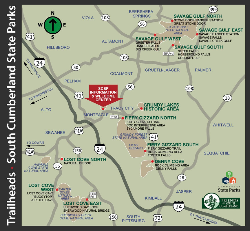
New Fiery Gizzard Trail Bridge now open
The replacement footbridge that marks the start of the Fiery Gizzard Trail in the Grundy Forest State Natural Area of South Cumberland State Park, about 3/4 of a mile from the Fiery Gizzard North trailhead, is now open. The previous wooden bridge was washed out during heavy winter rains in early 2020. The new bridge, with all-aluminum construction, features a slightly longer span and aluminum piers, set in concrete; the new design is less likely to be impacted by periods of high water in the creek. Park Managers note that new approach trails on either side of the bridge are still being worked on, to connect the bridge with the existing trail system in this area of the Park. They appreciated everyone's patience as this much-awaited piece of trail infrastructure was put in place.
The replacement footbridge that marks the start of the Fiery Gizzard Trail in the Grundy Forest State Natural Area of South Cumberland State Park, about 3/4 of a mile from the Fiery Gizzard North trailhead, is now open. The previous wooden bridge was washed out during heavy winter rains in early 2020. The new bridge, with all-aluminum construction, features a slightly longer span and aluminum piers, set in concrete; the new design is less likely to be impacted by periods of high water in the creek. Park Managers note that new approach trails on either side of the bridge are still being worked on, to connect the bridge with the existing trail system in this area of the Park. They appreciated everyone's patience as this much-awaited piece of trail infrastructure was put in place.
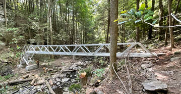
Look for 16 new Interpretive Panels throughout the Parks!
New interpretive panels have been installed to highlight history and nature in many areas of the park. A total of 16 new panels have been placed along SCSP trails. The panels highlight areas of historical interest and natural science. Look for these panels as you hike the Park's trails this fall!
The panels can be found on trails in the Grundy Lakes Historical Area and the Grundy Forest State Natural Area of South Cumberland State Park, and in several areas Savage Gulf State Park, with topics ranging from the Lone Rock Coke Ovens to the Chickamauga Trace to Savage Gulf Homesteaders to the Chimneys rock formation to the Werner Old Growth Forest and even two panels that explain the history of moonshine in this area.
In particular, two panels have been installed on trails that have some of the best wildflower watching in the state. Near the Savage Gulf North (Stone Door/Big Creek Gulf) and Savage Gulf South (Collins Gulf) trailheads, visitors will find innovative panels that allow them to download an electronic wildflower identification guide, using the camera on most current-generation smartphones.
The identification guide is actually a PDF file that can be downloaded to the visitor’s phone by scanning a QR code embedded on the interpretive panel. The guide is organized by flower color, with an additional sections describing flowering shrubs and trees, as well as different types of ferns. Over 100 wildflower varieties are listed, along with 15 different types of ferns and 17 kinds of flowering trees and shrubs. By downloading the identification resource at the trailhead, visitors will have the wildflower guide at their disposal, wherever they are in the park, whether they have a cell signal on the trail or not. Additional wildflower panels are planned for other trailheads in the parks as well.
Twelve of the panels were funded by the Friends of South Cumberland; the Wildflower panels are being funded with grants from the Tennessee Iris Fund and the Friends of Tennessee State Parks; and two of the panels related to Prescribed Burn forestry practices are funded by a grant from the Tennessee Wildlife Federation.
Open Space Institute’s Earth Day presentation
features South Cumberland, SCSP and SGSP
The Open Space Institute, one of our outstanding conservation partners,
chose to feature SCSP, SGSP and the South Cumberland region as part of its Earth Day 2020 celebration.
Take a few minutes to scroll through the interactive presentation:
https://osiny.maps.arcgis.com/apps/Cascade/index.html
The Friends of South Cumberland were happy to supply some of the photos and video for the presentation.
Thanks to OSI for recognizing the Friends and our amazing South Cumberland and Savage Gulf State Park teams!